Campeche
A Mexican state with a colonial capital and offshore oil wealth.

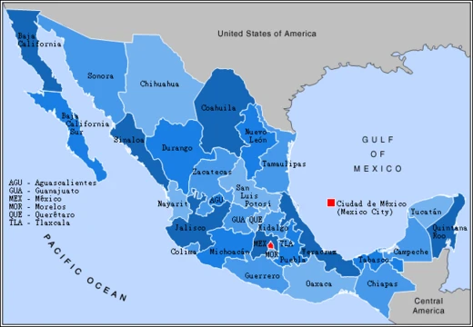
Campeche is one of Mexico’s 31 states, and together with Mexico City, it forms one of the country’s 32 federal entities. It sits in the southeastern part of Mexico, bordering Tabasco to the southwest, Yucatán to the northeast, Quintana Roo to the east, Guatemala’s Petén department to the south, and Belize’s Orange Walk District to the southeast. Its western side meets the Gulf of Mexico. The state’s capital, also named Campeche, became a UNESCO World Heritage Site in 1997. The state grew out of this city, which the Spanish founded in 1540 as they began taking over the Yucatán Peninsula. During colonial times, Campeche was a wealthy and significant port, but its fortunes faded after Mexico gained independence. For a long time, it belonged to the province of Yucatán, but it broke away in the mid-1800s, mainly because of political tensions with Mérida. More recently, the state’s economy has bounced back thanks to offshore oil discovered in the 1970s, turning the coastal cities of Campeche and Ciudad del Carmen into key economic hubs. While Campeche has important Mayan and colonial ruins, they draw fewer visitors than other sites in the Yucatán.
The name “Campeche” comes from *Can Pech*, the Maya name for a chiefdom in the southwestern Yucatán Peninsula that existed when Spanish conquistadors arrived in the 1500s. The chiefdom’s capital, called “Ah-Kin-Pech,” stood where the city of Campeche is now. When the Spanish first reached the area in 1517, they named it Lazaro because they landed on St. Lazarus’ Sunday. The native name means “place of snakes and ticks.”
Geographically, Campeche is mostly flat, with 523 kilometers (325 miles) of Gulf of Mexico coastline. Its surface is largely sedimentary rock, much of it originally formed under the sea. The highest areas lie near the borders with Guatemala and Quintana Roo, with hills like Cerro Champerico, Cerro los Chinos, Cerro El Ramonal, Cerro El Doce, and Cerro El Gavilán, though these are separated by wide stretches of low, flat land. In the south of Champotón municipality, a range of rolling hills called the Sierra Alta or Puuc begins, running northeast to Bolonchen and into Yucatán. These hills average just 40 to 60 meters (130 to 200 feet) in height, with some reaching 100 meters (330 feet). Other rolling hills near the city of Campeche include Maxtum, Boxol, and El Morro, while another set, the Sierra Seybaplaya, lies in the state’s center.
The rainforest here comes in several types: perennial tall tree, semi-perennial tall tree, deciduous medium height, semi-deciduous medium height, deciduous low height, and semi-perennial low height. Away from the coast, these forests mix with savannahs, and along the coast, sand dunes, mangrove wetlands, and estuaries appear. Common rainforest trees include Spanish cedar (*Cedrela odorata*), oxhorn bucida (*Bucida buceras*), Campeche logwood (*Haematoxylum campechianum*), and wild tamarind (*Lysiloma latisiliquum*). Valuable tropical hardwoods such as red cedar (*Toona ciliata*), Honduran mahogany (*Swietenia macrophylla*), ziricote (*Cordia dodecandra*), and Hollywood (*Guaiacum sanctum*) also grow here. Along the coast, palms like the coconut tree (*Cocos nucifera*) and royal palm (*Roystonea regia*) dominate. Wildlife includes jaguars, ocelots, pumas, deer, collared peccaries, raccoons, hares, ring-tailed cats, and Yucatan spider monkeys. Birds range from plain chachalacas and quail to pelicans and toucans. Reptiles include rattlesnakes, coral snakes, boa constrictors, various sea and land turtles, iguanas, and crocodiles. Although still rich in wildlife, much has been lost to agriculture, forest exploitation, habitat destruction, and uncontrolled hunting. Most of the state’s aquatic life—fish, crustaceans, and mollusks—lives in the Bay of Campeche, and many are harvested commercially.
Most of Campeche’s surface freshwater is in the south and southwest, with rivers, small lakes, and estuaries. These diminish in the north, where rain quickly soaks into the ground. The southern rivers belong to several basins, the largest being the Grijalva, which includes the Candelaria, Chumpán, and Mamantal Rivers. The Usumacinta River also flows through the state, often changing course and splitting into branches. Its eastern branch, the Palizada River, is narrow but carries the most water. Another branch, the San Pedro River, passes through Tabasco’s Jonuta Municipality before emptying into the Gulf of Mexico. The Chumpán River forms from several streams, runs north–south, and drains into the Laguna de Terminos. The Candelaria River starts in Petén, Guatemala, flows north–south, and empties into the Laguna de Pargos. The Mamantel River drains into the Laguna de Panlau. The Champotón River, in the state’s center, flows into the Gulf of Mexico. The rest of the state’s streams only flow during the rainy season. The Laguna de Términos lagoon lies in the southwest, near the Tabasco border, separated from the Gulf of Mexico only by Isla del Carmen, and it receives freshwater from several rivers.
The state’s executive power is held by the governor of Campeche, and its legislative power by the Congress of Campeche, a unicameral body with 35 deputies.
- Capital
- Campeche
- Statehood
- Mid-19th century (split from Yucatán)
- Country
- Mexico
- Known for
- Petroleum discovery in the 1970s, Mayan and colonial sites, World Heritage capital
Lore & Background
The name Campeche is derived from Can Pech, the Maya name of a chiefdom of the southwestern Yucatán Peninsula that existed at the time of the arrival of the Spanish conquistadors in the sixteenth century. The capital city of the chiefdom of Can Pech was called 'Ah-Kin-Pech', where the city of Campeche is now. Lazarus' Sunday'. The native name means 'place of snakes and ticks'. Most of the surface is of sedimentary rock, much of it of marine origin. The area with the highest elevations is near the borders with Guatemala and Quintana Roo. Notable elevations include Cerro Champerico, Cerro los Chinos, Cerro El Ramonal, Cerro El Doce, and Cerro El Gavilán. However, these hills are separated by large expanses of lower flat land. In the south of the municipality of Champotón begin a series of rolling hills known as the Sierra Alta or Puuc, which extend northeast to Bolonchen and then into the state of Yucatán. Other areas of these rolling hills lie near the city of Campeche, the main ones known as Maxtum, Boxol and El Morro. Another set is called the Sierra Seybaplaya in the center of the state. Rainforest areas subdivide into a number of types which include perennial tall tree rainforest, semi perennial tall tree rainforest, deciduous medium height tree rainforest, semi-deciduous medium height tree rainforest, deciduous low height tree rainforest and semi-perennial low height tree rainforest. Away from the coast, these rainforests are interspersed with savannah areas and along the coast are accompanied by areas with sand dunes, mangrove wetlands and estuaries. Species that can be found in the various rainforests include Spanish cedar, oxhorn bucida, Campeche logwood, and wild tamarind. It also includes a number of precious tropical hardwoods such as red cedar, Honduran mahogany, ziricote and Hollywood. Along the coastal areas, palms dominate such as the coconut tree and royal palm. The main wildlife species in the state are the jaguar, ocelot, puma, deer, collared peccary, raccoon, hare, ring-tailed cat and Yucatan spider monkey. There are many bird species including the plain chachalaca, quail, pelican, and toucan. Reptiles include rattlesnakes, coral snakes, boa constrictors, various species of sea and land turtles, iguanas, and crocodiles.
Reader's Guide
Campeche's significance lies in its dual heritage as a colonial port and a modern petroleum hub. After Mexico's independence, the city declined, but the discovery of offshore petroleum in the 1970s spurred an economic revival, making coastal cities like Campeche and Ciudad del Carmen important economic centers. The state also contains important Mayan and colonial sites, though these are less visited than those elsewhere in the Yucatán Peninsula. Politically, Campeche's executive power rests in the governor, and legislative power in the Congress of Campeche, a unicameral legislature of 35 deputies. The state's geography is predominantly flat with sedimentary rock, featuring rainforests, savannahs, and coastal mangroves. Its ecosystems support diverse wildlife, including jaguars, ocelots, and toucans, though habitat destruction and hunting have reduced populations. The Laguna de Términos lagoon system in the southwest is the most important lake-lagoon system in the country, supporting aquatic species like sea bass, crabs, and oysters. Campeche's climate is tropical with a rainy season and occasional hurricanes in late summer.
Did You Know?
- The name Campeche comes from the Maya 'Can Pech', meaning 'place of snakes and ticks'.
- Campeche split from the province of Yucatán in the mid-19th century due to political friction with Mérida.
- Offshore petroleum discovered in the 1970s revived the state's economy.
Frequently Asked Questions
What is Campeche most known for?
The state is widely recognized for the offshore petroleum reserves tapped in the 1970s, as well as its Mayan archaeological sites and the well-preserved colonial architecture in its capital.
Where is Campeche located and what borders it?
Campeche sits in southeast Mexico, bordered by Tabasco, Yucatán, and Quintana Roo, with Guatemala's Petén department and Belize's Orange Walk District to the south and southeast. The Gulf of Mexico lies to its west.
More in Mexican States 1-19
Spotted an error? Know more?
This is a living reference — every entry is fact-audited, and reader corrections feed straight into our audit queue. Suggest an edit · See this site's audit record