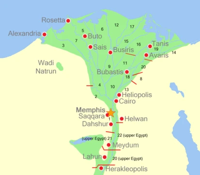
Middle Egypt
Middle Egypt bridges the Nile Delta and Upper Egypt.

via Wikipedia: Middle Egypt · see source
Middle Egypt is the section of the Nile Valley between Lower Egypt and Upper Egypt, stretching from Asyut in the south to Memphis in the north. Although technically a subdivision of Upper Egypt in ancient times, the term was coined by 19th-century archaeologists to describe the river stretch between Cairo and the Qena Bend. Today, the region is culturally closer to Lower Egypt, with its northern dialects sharing features with Cairene and Delta Arabic rather than the Sa'idi Arabic of the south.
Quick Facts
- Southern boundary
- Asyut
- Northern boundary
- Memphis
- Alternative ancient name
- Heptanomis
- Meaning of heptanomis
- Seven Nomes
- Latitudinal extent
- 27°4′ North to 30° North
- Southern limit of heptanomis
- Castle of Hermopolis
- Northern limit of heptanomis
- Apex of the Delta and town of Cercasorum
Facts from the source article.
Did You Know?
- Under the Ptolemies, the Heptanomis was governed by an ἐπιστράτηγος (viceroy/prefect), and under the Roman Caesars by a procurator Augusti epistrategiae Septem Nomorum.
- The capital cities of the Heptanomis were collectively called the Heptapolis, meaning 'Seven Cities': Memphis, Heracleopolis, Crocodilopolis (later Arsinoe), Aphroditopolis, Oxyrhynchos, Cynopolis, and Hermopolis.
Heptanomis
The Heptanomis, meaning "Seven Nomes," was described in the 19th century as the district separating the Thebaïd from the Delta. Its boundaries are difficult to define precisely because the appellation was political rather than territorial. The northern part belonged to the kingdom of Lower Egypt and contained its capital, Memphis, while the southern part belonged to the elder kingdom of Thebes, at least as long as two monarchies existed in the Nile valley. It is not possible to determine at what period, if ever, the Heptanomis was regarded as an integral third of Egypt. The number of its nomes is certain, but which seven were principal at any given era is less clear, as they likely varied with local prosperity, war, commerce, or migration. According to Ptolemy and Agatharchides, the Seven Nomes were: Memphites, Heracleopolites, Crocodilopolites (renamed Arsinoites), Aphroditopolites, Oxyrhynchites, Cynopolites, and Hermopolites. The Greater and Lesser Oases were always considered parts of the Heptanomis, so it apparently sent nine nomarchs to the general assembly in the Labyrinth. The capitals of the nomes, indicated by the division names, were the chief towns of the Middle Land. The district contained three great works: the Pyramids, the Labyrinth, and the artificial district formed by the canal Bahr Yusif (the Nomos Arsinoites or the Fayyum). The Heptanomis extended from latitude 27°4′ North to 30° North, bounded to the south by the castle of Hermopolis, to the north by the apex of the Delta and the town of Cercasorum, to the west by the irregular line of the Libyan Desert, and to the east by the hills confining the Nile or the sinuous outline of the Arabian mountains. Near Hermopolis at the southern extremity, the eastern hills approached the river closely, while those on the western bank receded to a considerable distance.
More in Geography of Ancient Egypt
Spotted an error? Know more?
Reader corrections go straight into our review queue. Suggest an edit · How this site is sourced