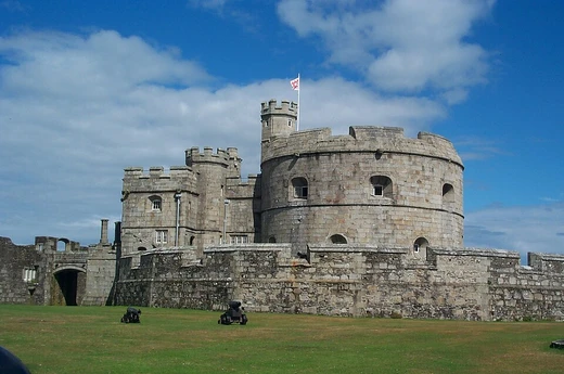
Tilbury Fort
A Thames-side artillery fort with Britain's finest 17th-century defences.
Last updated

via Wikipedia: Tilbury Fort · see source
Where it is
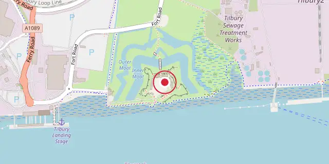
Coordinates: 51°27′11″N 0°22′30″E (51.4530, 0.3750) · Open in OpenStreetMap
Coordinates and connected clubs: the infobox of Wikipedia: Tilbury Fort (CC BY-SA 4.0). Map: drawn by Codexery from OpenStreetMap tiles.
Tilbury Fort, also called the Thermitage Bulwark and West Tilbury Blockhouse, sits on the River Thames's north bank in England. Henry VIII built the first version, a small blockhouse with artillery covering the river, to protect London from France as part of his Device programme. After the 1588 Spanish Armada scare, earthwork bastions were added, and Sir Bernard de Gomme enlarged it from 1670 into a star-shaped fort with angular bastions, water-filled moats, and two lines of guns facing the river. The 17th-century defences are considered by historian Paul Pattison the "best surviving example of their kind in Britain."
Last updated 2026-11-03 from the source article.
Did You Know?
- The fort's original name, the Thermitage Bulwark, came from a hermitage dissolved by Henry VIII in 1536.
- Queen Elizabeth I visited the fort by barge on 8 August 1588 and gave a speech to the assembled army nearby.
- During the 1667 Dutch raid, only two guns at Tilbury were ready for action.
- Around 3,000 timber piles were brought from Norway in 1671 to support the fort's foundations in marshy ground.
History
The first permanent fortification at Tilbury in Essex resulted from international tensions between England, France and the Holy Roman Empire in the final years of Henry VIII's reign. In response, Henry issued a "device" in 1539 for the defence of the realm and the construction of coastal forts.
The River Thames was strategically important because London and the royal dockyards of Deptford and Woolwich were vulnerable to seaborne attack up the estuary, which carried 80 per cent of England's exports. The Thames narrowed considerably at this point, forming a natural hub for the Long Ferry and Cross Ferry, and it was the first place an invasion force could easily disembark. Temporary defences had existed at Tilbury in the 14th and 15th centuries, though little is known about their design.
Architecture
Tilbury Fort remains largely unaltered from its late 17th-century reconstruction under Sir Bernard de Gomme, with some 19th-century additions. It was designed in a predominantly Dutch style, with outer and inner defences to attack hostile warships while being protected from land attack. The outer defences consist of outer and inner water-filled moats fed by the Thames, separated by a ring of ramparts; the inner moat is 50 m wide and relatively shallow, with banks strengthened by piles.
The fort is entered from the north through a triangular redan, with a redoubt defending the entrance. A causeway links the redan to the outer defences, which include bastions on the north-west and north-east corners and two triangular spurs originally equipped with cannons. A replica wooden bridge crosses the water to a ravelin, linked to the inner defences by another replica bridge protected by two drawbridges. On the south side, facing the river, are the West and East Lines of gun positions built in the 18th century; 12 of the original 14 gun positions on the West Line remain, but only one of the East Line has survived.
A quay allowed supply delivery from the Thames, and a sluice gate in the south-west corner could drain the moats to prevent freezing. To the west of the outer defences is the World's End pub, originally the local ferry house, dating from 1788.
Outer defences
The outer defences consist of two water-filled moats fed by the Thames, separated by defensive ramparts. The inner moat is 50 meters wide and shallow, with banks reinforced by piles. Entry is from the north through a redan, a triangular defensive work, with a redoubt guarding the entrance. A causeway connects the redan to the outer defences, which include ramparts, a covered way, bastions at the north-west and north-east corners, and two triangular spurs originally equipped with cannons on the west and east sides, with infantry assembly points inside.
A replica wooden bridge leads from the outer defences to a ravelin island, linked to the inner defences by another replica bridge with two drawbridges. The ravelin blocked incoming artillery fire and could fire on enemies breaching the outer line. On the south side, the West and East Lines of gun positions were built in the 18th century; 12 of 14 West Line positions remain, but only one East Line survives. Between them is a quay for Thames supply deliveries and remains of First World War narrow-gauge railway tracks.
A sluice gate in the south-west controlled moat water, allowing drainage to prevent freezing. West of the defences stands the World's End pub, originally a ferry house from 1788.
Inner defences
The inner defences follow a pentagonal design with four bastions around a central parade ground. Entry from the south is through the Water Gate, a two-storeyed late-17th-century gatehouse with a stone facade carved with classical and 17th-century weapons; its empty niche likely held a statue of King Charles II. The building originally housed the master gunner. The parade ground covers 2.5 acres, raised with chalk and dirt in the 17th and 19th centuries, and once held four large warehouses, now destroyed.
The south-eastern curtain and bastion were rebuilt in the early 20th century for four quick-firing guns and two 6-inch guns, with tunnels to an underground magazine; four artillery pieces from 1898 to 1942 are on display. Officers' quarters, a late-18th-century terrace, face the parade ground, with a stables at the north end that now holds the Bernard Truss military memorabilia collection. The north-east bastion, redesigned after 1868, contains an earth-covered magazine and emplacements for 9-inch rifled muzzle loading guns.
On the north side are two early-18th-century magazines, altered in the 19th century, built without iron to avoid sparks, using wood and copper; they are the only surviving examples in Britain. The Landport Gate, with a gatehouse called the Dead House, lies behind them. The soldiers' barracks opposite the officers' quarters were destroyed after the war, leaving only foundations. The south-west magazine has a covered magazine like the north-east one.
West of the Water Gate is the guardhouse and chapel, late 17th century, one of the oldest surviving places of worship in a British artillery fortress.
More in Device Forts
Sources
Compiled from Wikipedia and the sources listed below. Text from Wikipedia is available under CC BY-SA 4.0; this entry is adapted from it.
- Wikipedia: Tilbury Fort (CC BY-SA 4.0).
- Word definitions: the Codexery glossary, each quoted from its Wikipedia article.
Spotted an error? Know more?
Reader corrections go straight into our review queue. Suggest an edit · How this site is sourced