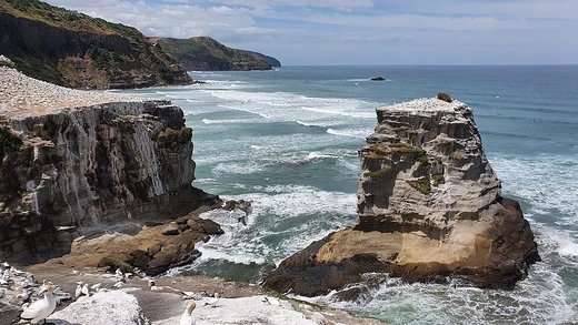
Cliffs of Moher
Sea cliffs on Ireland's Atlantic coast, a major tourist destination.

The Cliffs of Moher (Irish: Aillte an Mhothair) sit at the southwestern edge of the Burren region in County Clare, Ireland, stretching for about 14 kilometres. At their southern tip, known as Hag's Head, they rise 120 metres above the Atlantic Ocean. About 8 kilometres north, just past O'Brien's Tower—a round stone tower built in 1835 by Sir Cornelius O'Brien near the cliffs' midpoint—they reach their maximum height of 214 metres, then gradually become lower. The nearest villages are Liscannor, 6 kilometres to the south, and Doolin, 7 kilometres to the north.
The name comes from an old promontory fort called Mothar or Moher, which once stood on Hag's Head, now the site of Moher Tower. Writer Thomas Johnson Westropp referred to it in 1905 as Moher Uí Ruis or Moher Uí Ruidhin. The fort was still standing in 1780, as mentioned in John Lloyd's *A Short Tour of Clare*, but it was demolished in 1808 to provide stone for a lookout and telegraph tower built to warn of a possible French invasion during the Napoleonic wars.
From the cliffs and O'Brien's Tower, visitors can see the Aran Islands in Galway Bay, the Maumturks and Twelve Pins mountain ranges to the north in County Galway, and Loop Head to the south. The cliffs are one of Ireland's most popular tourist sites, drawing around 1.5 million visits per year. In 2006, they topped a list of attractions with nearly one million visitors at the official visitor centre and about half a million elsewhere. By 2022, about 1.1 million people visited, 41% of them from the United States. The visitor experience recorded 1,427,000 visits in 2016, up 14% from 2015, and 1,527,000 in 2017, making it the second most popular fee-charging attraction in the country. That rose by 3.8% in 2018 to 1,580,010 visits.
Since 2011, the cliffs have been part of the Burren and Cliffs of Moher Geopark, a UNESCO-recognized member of the European Geoparks Network. They are also a "signature point" on the Wild Atlantic Way tourist trail. The cliffs can be accessed at multiple points, and there is an 18-kilometre Cliff Walk. Most visitors come to the official visitor centre.
In the 1990s, Clare County Council began work on a modern visitor centre, the Cliffs of Moher Visitor Experience, built into a hillside to minimize intrusive amenities. It uses renewable energy systems, including geothermal heating and cooling, solar panels, and grey water recycling. The €32 million facility took 17 years to plan and build, opening in February 2007. Exhibits include interactive media on the cliffs' geology, history, flora, and fauna, plus a large multimedia screen showing a bird's-eye view and video from underwater caves. There are two cafés and several shops.
To manage overcrowding, visitors are encouraged to come at off-peak times, with discounts for coach operators who book off-peak slots and late opening hours in July and much of August. Automatically opening exit gates from the official car park also help later arrivals.
The Cliffs of Moher Visitor Experience won an award in the Interpret Britain & Ireland Awards 2007 from the Association of Heritage Interpretation, specifically for the Atlantic Edge exhibition, though the judges assessed the entire site and called it "one of the best facilities that the judges had ever seen."
The official Cliffs of Moher Coastal Walk runs 14 kilometres from Hag's Head to Doolin, passing the Visitor Centre and O'Brien's Tower. Near the centre, there are two paths: the official one set back for safety, and an unofficial one closer to the edge. In July 2016, the Cliff Walk outside the official amenities was temporarily closed due to rockfall risk, and people were warned to stay on the official path. Despite signage and prevention efforts, injuries and casualties from straying off the trail continued. In February 2025, the coastal walking trail was closed for safety reasons and remained closed as of September 2025. Ferry trips also let tourists view the cliffs from sea level, and at certain times, fixed-wing aircraft from Connemara Airport offer aerial views.
The cliffs are made mainly of Namurian shale and sandstone, with the oldest rocks at the bottom. They formed between 313 and 326 million years ago when a river deposited sand, silt, and clay into an ancient marine basin. Over millions of years, these sediments compacted and lithified into the sedimentary strata now exposed. The area is considered a geologic laboratory preserving a record of deltaic deposition in deep water. Individual strata vary from a few centimetres to several metres thick, each representing a specific depositional event. In total, up to 200 metres of sedimentary rock are exposed.
- location
- Southwestern edge of the Burren, County Clare, Ireland
- length
- 14 kilometres (9 miles)
- nearest_settlements
- Liscannor 6 km south, Doolin 7 km north
- annual_visitors
- Approximately 1.5 million
Lore & Background
The cliffs take their name from an old promontory fort called Mothar or Moher, which once stood on Hag's Head, the southernmost point.
Reader's Guide
The Cliffs of Moher are a key part of the Burren and Cliffs of Moher Geopark, recognized by UNESCO, and a signature point on the Wild Atlantic Way tourist trail. The cliffs consist mainly of Namurian shale and sandstone, with up to 200 metres of sedimentary rocks exposed. They are subject to erosion by wave action, creating sea caves, sea stacks, and sea stumps. A modern visitor centre, the Cliffs of Moher Visitor Experience, opened in February 2007 after 17 years of planning and construction, costing €32 million. It won an award in the Interpret Britain & Ireland Awards 2007. The cliffs have appeared in films such as The Princess Bride, Harry Potter and the Half-Blood Prince, and Leap Year, and in music videos by Maroon 5 and Westlife.
Frequently Asked Questions
What are the Cliffs of Moher?
The Cliffs of Moher are a dramatic stretch of Atlantic sea cliffs on Ireland's west coast, forming the southwestern boundary of the Burren area in County Clare. In Irish, they are called Aillte an Mhothair.
Where exactly are the Cliffs of Moher located?
They sit along the Atlantic shoreline in County Clare, with the town of Liscannor roughly six kilometres to the south and Doolin about seven kilometres to the north. The entire cliff face stretches for approximately fourteen kilometres of coastline.
How many people visit the Cliffs of Moher each year?
Approximately 1.5 million visitors make the trip to the site annually, making it one of the most popular natural attractions in all of Ireland. Its combination of sheer height, sweeping Atlantic views, and accessible viewpoints keeps it a top draw for tourists.
More in Coastal And Marine Features 1-24
Spotted an error? Know more?
This is a living reference — every entry is fact-audited, and reader corrections feed straight into our audit queue. Suggest an edit · See this site's audit record