
Hexi Corridor
A historic corridor linking China to Central Asia.

via Wikipedia: Hexi Corridor · see source
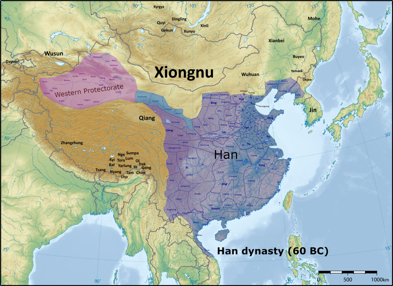
The Hexi Corridor, sometimes called the Gansu Corridor, is a historically significant region in what is now western Gansu Province, China. It is a narrow, relatively fertile plain lying west of the Yellow River’s Ordos Loop—hence its name, which means “west of the river.” This corridor sits between the far higher and harsher landscapes of the Mongolian Plateau to the north and the Tibetan Plateau to the south. For thousands of years, it facilitated the exchange of crops, livestock, and culture between China and the rest of Eurasia, both in prehistoric times and, after the Han Dynasty, as a key segment of the Northern Silk Road.
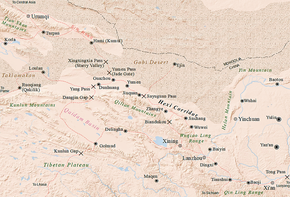
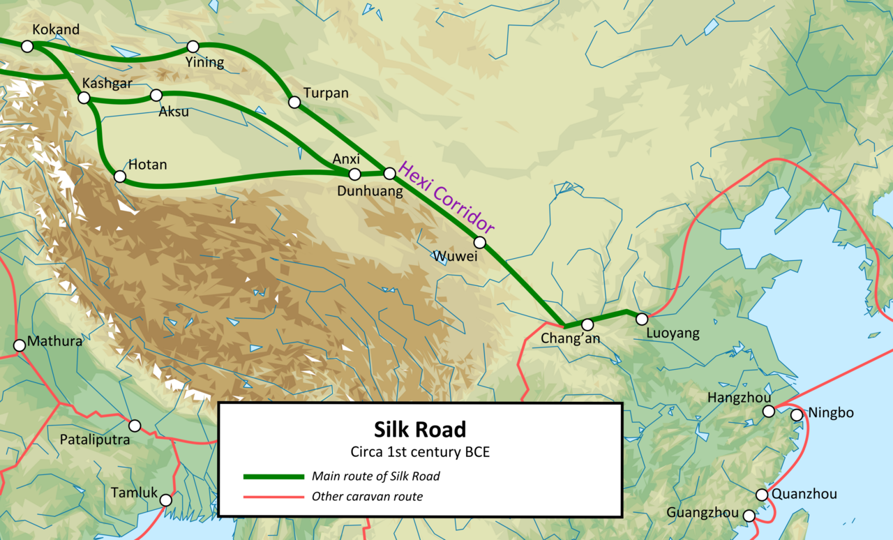
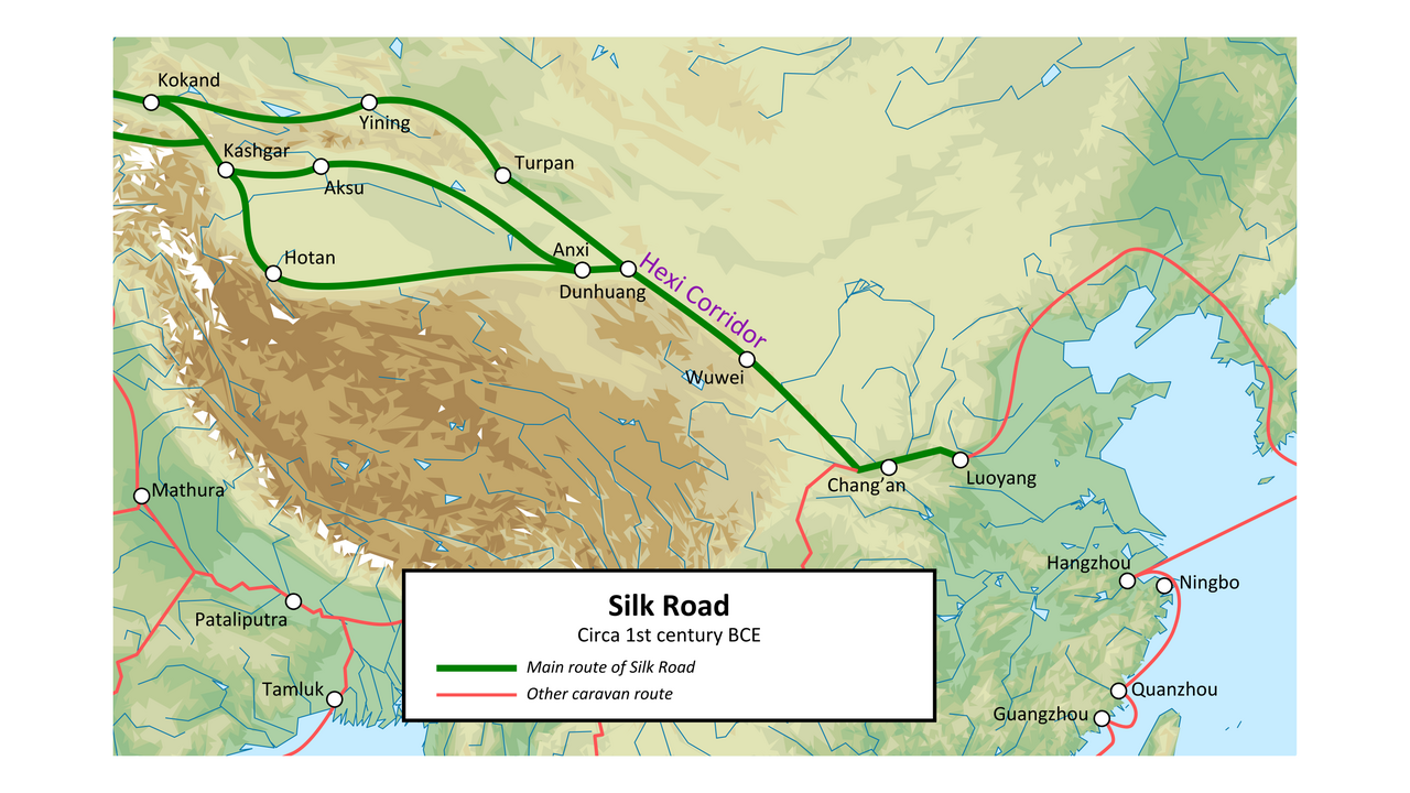
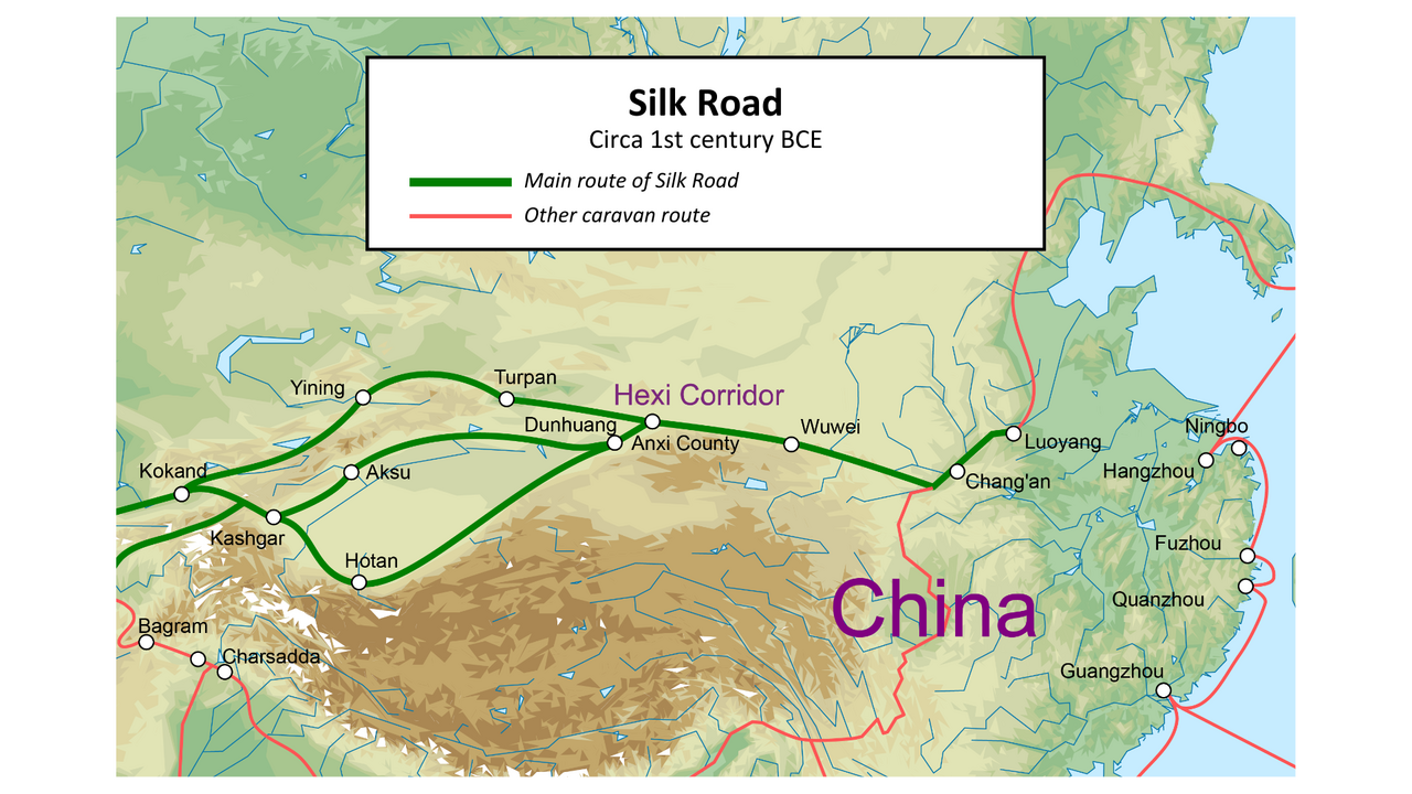
As part of the Northern Silk Road, the Hexi Corridor ran northwest from the western side of the Ordos Loop, between Yinchuan and Lanzhou, making it the most vital trade route in northwestern China. It connected China proper to the historic Western Regions, serving both merchants and military campaigns into Central Asia. The corridor is a chain of oases along the northern foothills of the Qilian Mountains and the Altyn-Tagh range. To the south lies the high, barren Tibetan Plateau. To the north, the Longshou, Heli, and Mazong Mountains separate it from the arid Badain Jaran Desert, the Gobi Desert, and the cold steppes of the Mongolian Plateau. At its western end, the route splits into three branches: one north of the Tianshan Mountains, and two south of the Tarim Basin on either side. At its eastern end, the mountains around Lanzhou provide access to the Longxi Basin, which leads east through Mount Long along the Wei River valley to the populous Guanzhong Plain, and then onward to the Central Plain.
**Geography**
The Hexi Corridor covers much of northwestern Gansu Province, lying west of the Yellow River as it curves north around the Ordos Loop. It stretches roughly 1,100 kilometers (680 miles) from the Wushao Mountains in the east to Yumen Pass in the west, and extends 100–200 kilometers (60–100 miles) from north to south. Its width ranges from 40 to 100 kilometers (20–60 miles), and it covers about 276,000 square kilometers (107,000 square miles)—roughly 60% of Gansu Province’s area. In 2011, its population was 4.82 million, about 19% of the province’s total. As of 2024, the corridor contains 20 administrative divisions and five prefecture-level cities: from east to west, Wuwei, Jinchang, Zhangye, Jiuquan, and Jiayuguan.
Elevation drops from about 1,500 meters (4,900 feet) above sea level in the southeast to around 1,000 meters (3,300 feet) in the northwest. The corridor is bordered by the Qilian Mountains to the south and southeast, the Kumtag Desert to the west, the Mazong, Helan, and Longshou Mountains to the north, the Badain Jaran Desert to the northeast, and the Tengger Desert to the southeast. The Qilian Mountains run along the southern edge for 600 kilometers (370 miles), with several peaks exceeding 4,500 meters (14,800 feet). The northern mountains are generally 1,500–2,500 meters (4,900–8,200 feet) high. Because it lies as a relatively low, fertile valley between these highlands, the Hexi Corridor is the most convenient route between China and Central Asia.
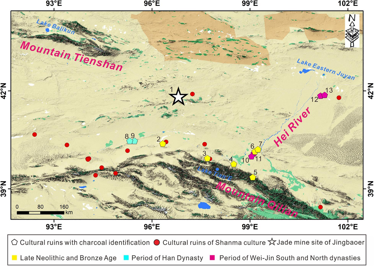
The three largest rivers in the corridor are the Shiyang, Heihe, and Shule. Like most rivers here, much of their water comes from melting glaciers and snow in the Qilian Mountains. They form extensive alluvial fans and inland drainage basins as they flow through the corridor, beyond which lie deserts and large sand-dune fields. Arid landscapes, including deserts, make up about 70% of the Hexi Corridor. Fertile land and vegetation are mostly limited to oases along the major rivers, which have supported both nomadic groups and settled societies for thousands of years.
**Geology**
The Hexi Corridor is a Cenozoic foreland basin formed over millions of years by the uplift, crustal shortening, and northward advance of the Tibetan Plateau, of which it forms the northeastern margin. The region is seismically active, having experienced five earthquakes of magnitude 7 or greater since 180 AD, and is dominated by northwest-trending reverse faults. It is internally divided by three uplifts into four depressions filled with thick fluvial and lacustrine sediment deposited during the Quaternary era.
The area of today’s Hexi Corridor was part of various foreland and strike-slip basins throughout the Paleozoic and early to mid-Mesozoic. During the Cretaceous, the region encompassing the corridor and the Qilian Mountains was lifted above its surroundings, and tectonic activity waned, so erosion dominated until the early Oligocene.
In the Oligocene, crustal shortening from the collision of India and Eurasia and the growth of the Tibetan Plateau caused the Hexi Corridor to down-fault and subside. It likely became the northern margin of a wide basin extending north from the Kunlun Mountains, interrupted by a low rise about 400 kilometers (250 miles) south of the corridor in what is now the southern Qilian Mountains. Sedimentation at that time was dominated by fine, highly eroded material from this low rise, transported by long meandering streams, and deposited in shallow terminal lakes within the basin.
Around 13 million years ago, during the Miocene, the northeastward propagation of the Altyn Tagh Fault reached its maximum extent at the Hexi Corridor. Subsequent crustal shortening around this new terminus formed the Qilian Mountains, separating the Qaidam Basin to the south from the Hexi Corridor. During the Pliocene and Pleistocene, crustal shortening spread into the corridor itself, creating multiple uplifts. Since the mid-Miocene, deposition in the Hexi Corridor has continued.
- location
- Western Gansu province, China
- length
- Approximately 1,100 km (680 mi)
- width
- 40–100 km (20–60 mi)
- area
- Approximately 276,000 km² (107,000 mi²)
- population_2011
- 4.82 million
- elevation_range
- 1,000–1,500 m (3,300–4,900 ft) above sea level
- major_rivers
- Shiyang, Heihe, Shule
Verified Timeline
Lore & Background
The Hexi Corridor is a Cenozoic foreland basin formed over millions of years by the uplift, crustal shortening, and northward advance of the Tibetan Plateau, a landform of which the Hexi Corridor forms the northeastern margin. The region is seismically active, having experienced five earthquakes of magnitude 7 or greater since 180 AD, and is dominated by northwest-trending reverse faults. It is internally divided by three uplifts into four depressions filled with thick fluvial and lacustrine sediment deposited during the Quaternary era. During the Oligocene, crustal shortening as a result of the India–Eurasia collision and the growth of the Tibetan Plateau caused the down-faulting and subsidence of the Hexi Corridor. During the Miocene (around 13 million years ago), the northeastward propagation of the Altyn Tagh Fault reached its maximum extent at the Hexi Corridor; subsequent crustal shortening around this new terminus led to the formation of the Qilian Mountains, separating the Qaidam Basin to the south from the Hexi Corridor. By 1.1 million years ago, the lakes and former river deltas had disappeared with the formation of rivers such as the Heihe and Shiyang, which cut through the former systems by running parallel down the length of the corridor rather than perpendicularly across it.
Reader's Guide
The Hexi Corridor's significance lies in its role as the most important trade route in Northwest China, linking China proper to the historic Western Regions for traders and military incursions into Central Asia. As part of the Northern Silk Road, running northwest from the western section of the Ordos Loop between Yinchuan and Lanzhou, it is a string of oases along the northern edges of the Qilian Mountains and Altyn-Tagh. At the western end, the route splits into three, going either north of the Tianshan Mountains or south on either side of the Tarim Basin. At the eastern end, the mountains around Lanzhou grant access to the Longxi Basin, which leads east through Mount Long along the Wei River valley into the populous Guanzhong Plain, and then into the Central Plain. The climate in the Hexi Corridor is heavily influenced by its location at the intersection of a humid zone in the east dominated by the East Asian monsoon and an arid zone in the west dominated by the westerlies. Between the Last Glacial Maximum and the late Holocene, the northern boundary of the East Asian Monsoon migrated at least 300 km northwest of its current location near Zhangye. From 4000–2000 BP, the East Asian monsoon retreated and the climate became cold and arid, leading to a period of cultural and agricultural decline in the region. Since 2000 BP, the influence of climate variability in the Hexi Corridor has increased; for instance, the abundance of early Han dynasty sites may be attributed to relatively warm and humid conditions at the time, while the Little Ice Age during the Ming to Qing dynasties likely contributed to the decline of the region's sites and the Silk Road.
Did You Know?
- The Hexi Corridor covers approximately 276,000 square kilometres, or around 60% of the area of Gansu Province.
- The region has experienced five earthquakes of magnitude 7 or greater since 180 AD.
- The three largest rivers in the Hexi Corridor—the Shiyang, Heihe, and Shule—derive most of their discharge from melting glaciers and snow in the Qilian Mountains.
- Arid landscapes such as deserts comprise roughly 70% of the Hexi Corridor.
- Between the Last Glacial Maximum and the late Holocene, the northern boundary of the East Asian Monsoon migrated at least 300 km northwest of its current location near Zhangye.
Geographic Position & Strategic Significance
The Hexi Corridor—literally 'west of the river,' named for its position on the western side of the Yellow River's Ordos Loop—occupies a narrow, relatively arable plain in modern western Gansu province. Stretching roughly 1,100 kilometres from the Wushao Mountains in the east to Yumen Pass in the west, it spans 100 to 200 kilometres north to south, ranges from 40 to 100 kilometres in width, and covers approximately 276,000 square kilometres, or about 60 percent of Gansu's total area. What makes this strip so consequential is what surrounds it: to the south and southeast rise the Qilian Mountains, whose peaks exceed 4,500 metres, while to the north the Longshou, Heli, and Mazong Mountains (generally 1,500 to 2,500 metres) separate the corridor from the Badain Jaran Desert, the Gobi, and the cold steppes of the Mongolian Plateau. Sandwiched between these inhospitable elevated terrains, the corridor's low-lying, traversable valley makes it the single most practical passage connecting China proper to Central Asia.
Silk Road & Cultural Exchange
For millennia, the Hexi Corridor served as the principal artery of the Northern Silk Road, enabling cultural and agricultural exchange between China and the broader Eurasian world. Running northwest from the western section of the Ordos Loop between Yinchuan and Lanzhou, it linked China proper to the historic Western Regions, facilitating both commercial trade and military incursions into Central Asia. The route traces a string of oases along the northern edges of the Qilian Mountains and Altyn-Tagh, with the desolate Tibetan Plateau lying further south. At its western terminus, the corridor splits into three branches—passing north of the Tianshan Mountains or threading along either side of the Tarim Basin. At the eastern end, the mountains around Lanzhou open onto the Longxi Basin, which then leads eastward through Mount Long along the Wei River valley into the densely populated Guanzhong Plain and onward to the Central Plain. This unbroken chain of passable terrain made the corridor the most important trade route in Northwest China, a role it sustained from prehistory through the Han Dynasty and beyond.
Hydrology & Arid Ecology
Despite its vast expanse, roughly 70 percent of the Hexi Corridor consists of arid landscapes—deserts and sand-dune fields. Life and settlement are concentrated in oases along three principal rivers: the Shiyang, the Heihe, and the Shule. These waterways derive most of their discharge from melting glaciers and snow in the Qilian Mountains to the south. As they flow through the corridor, they form extensive alluvial fans and inland drainage basins before reaching the deserts beyond. This pattern of river-fed oases has sustained both nomadic groups and settled agricultural communities for thousands of years, creating a fragile but persistent ribbon of fertility amid otherwise barren terrain. The elevation of the corridor itself descends from around 1,500 metres in the southeast to roughly 1,000 metres in the northwest, a gentle gradient that channels water and sediment from the high Qilian peaks down into the low-lying basin. The result is a landscape where human habitation has always been inseparable from access to meltwater, and where the boundary between civilization and desert is defined by the reach of a few great rivers.
Geological Formation & Seismic Activity
The Hexi Corridor is a Cenozoic foreland basin, shaped over millions of years by the northward advance, uplift, and crustal shortening of the Tibetan Plateau, of which the corridor forms the northeastern margin. During the Oligocene, the India–Eurasia collision triggered down-faulting and subsidence, likely making the region the northern edge of a wide basin extending from the Kunlun Mountains. In the Miocene, around 13 million years ago, the northeastward propagation of the Altyn Tagh Fault reached its maximum extent at the corridor; subsequent shortening at this new terminus built the Qilian Mountains, separating the Qaidam Basin to the south. During the Pliocene and Pleistocene, crustal shortening spread into the corridor itself, forming multiple uplifts that divide it internally into four sediment-filled depressions. The region remains seismically active, dominated by northwest-trending reverse faults, and has experienced five earthquakes of magnitude seven or greater since 180 AD. By 1.1 million years ago, the terminal lakes that once filled the basin had vanished as river deltas prograded and the landscape shifted toward its present arid character.
Gallery
Frequently Asked Questions
What is the Hexi Corridor?
The Hexi Corridor (also called the Gansu Corridor) is a long, narrow strip of arable land in western Gansu province, China, sitting just west of the Yellow River's Ordos Loop. It stretches roughly 1,100 km in length and 40–100 km in width, forming a natural east-west passage through an otherwise difficult terrain.
Where exactly is the Hexi Corridor located and how big is it?
It occupies about 276,000 km² of western Gansu at elevations between 1,000 and 1,500 m above sea level. As of 2011 the corridor's population was around 4.82 million people, making it a surprisingly populated stretch for such a narrow geographic feature.
Why is the Hexi Corridor historically important?
For millennia it was the principal overland route linking China proper to the Western Regions and Central Asia, making it indispensable for trade, agriculture, and cultural exchange. After the Han Dynasty it became a core segment of the Northern Silk Road, cementing its role as one of the most strategically vital corridors in Chinese history.
What made the Hexi Corridor a natural trade route?
Its long, relatively flat, and arable geography provided one of the few practical passages through an otherwise mountainous and arid region. Merchants, ideas, and crops could move east-west along this corridor far more easily than by detouring around the surrounding highlands and deserts.
How did the Hexi Corridor connect China to the wider world?
It functioned as the critical land bridge between the Chinese heartland and Central Asia, channeling goods, agricultural techniques, and cultural influences in both directions. Its strategic position meant that controlling the corridor largely meant controlling the flow of Silk Road commerce for centuries.
More in Chinese History 1-24
Spotted an error? Know more?
This is a living reference — every entry is fact-audited, and reader corrections feed straight into our audit queue. Suggest an edit · See this site's audit record