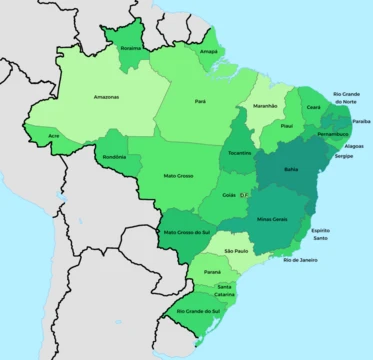
Southeast Region, Brazil
Richest and most populous region of Brazil.

via Wikipedia: Southeast Region, Brazil · see source
The Southeast Region of Brazil (Região Sudeste do Brasil) includes the states of Espírito Santo, Minas Gerais, Rio de Janeiro, and São Paulo. It is the country’s wealthiest region, generating about 53% of Brazil’s GDP in 2022. São Paulo, Rio de Janeiro, and Minas Gerais are the three richest states in Brazil, and the region as a whole has the highest GDP per capita. The Southeast also holds roughly 44% of Brazil’s total population, leading all regions in urban population, population density, number of vehicles, industries, universities, airports, ports, highways, hospitals, schools, and housing.
**Geography**
**São Paulo** The Ribeira Valley contains the largest continuous remnant of the Brazilian Atlantic Forest and is a UNESCO Biosphere Reserve. Its biological and ecosystem diversity is notable, with around 400 species of birds, amphibians, reptiles, and mammals. The Alto Ribeira Tourist State Park (PETAR) is a destination for ecotourists, featuring diverse geological formations such as grottos, caves, rivers, and waterfalls. The Brazilian Society of Speleology records 454 caves in São Paulo, all in the Ribeira Valley, and the 280 caves within PETAR form the highest concentration of caves in Brazil.
**Minas Gerais** The state’s landscape is marked by mountains, valleys, and caverns, with notable caves and waterfalls in Serra do Cipó, Sete Lagoas, Cordisburgo, and Lagoa Santa. Minas Gerais is the source of major Brazilian rivers, including the São Francisco, Paraná, and, to a lesser extent, the Rio Doce. It also hosts many hydroelectric plants, such as the Furnas dam. Some of Brazil’s highest peaks lie in the southern mountain ranges—Serra da Mantiqueira and Serra do Cervo—which border São Paulo and Rio de Janeiro. The most prominent is Pico da Bandeira, the third highest mountain in Brazil at 2,890 meters, located on the border with Espírito Santo. The state has large iron ore reserves and significant deposits of gold and gemstones, including emerald, topaz, and aquamarine.
**Rio de Janeiro** Rio de Janeiro is part of the Mata Atlântica biome, with a topography of mountains and plains between the Mantiqueira Mountains and the Atlantic Ocean. Its coastline is shaped by the bays of Guanabara, Sepetiba, and Ilha Grande. Steep slopes near the ocean create diverse environments, including restinga vegetation, bays, lagoons, and tropical forests. It is the smallest state in the Southeast and one of the smallest in Brazil, but it has the third longest coastline in the country (635 kilometers), after Bahia and Maranhão.
**Espírito Santo** Covering 46,180 square kilometers—about the size of Estonia or half of Portugal—Espírito Santo has varied habitats: coastal plains, lakes, mountain forests, mangroves, and more. The main river is the Doce; other important basins include the Santa Maria River Basin (northern branch) and the Jucu River Basin (southern branch), both flowing into the sea near Vitória. The climate is tropical along the coast, with dry winters and rainy summers. North of the Doce River it is generally drier and hot. In the mountainous south and southwest, altitude strongly influences the tropical climate, making average temperatures cooler. The state is divided into a low-lying coastal zone and a highland area called Serra, part of the larger Serra do Caparaó range. The 2,890-meter Pico da Bandeira mountain lies in this highland, shared with Minas Gerais.
**Demographics** *(Largest cities and racial groups are noted in the source but not detailed here.)*
**Economy**
**Agriculture** The region leads in many crops. It produces 85% of Brazil’s coffee (the world’s largest producer), 65% of its sugarcane, 85% of its oranges, 80% of its lemons, 90% of its peanuts, 35% of its bananas, 30% of its sorghum, 70% of its persimmons, 44% of its tomatoes, 60% of its tangerines, 40% of its papayas, 27% of its pineapples, and 13% of its cassava. It also grows more than 20% of the country’s beans, 7% of its soy, and over 50% of its potatoes, carrots, and strawberries.
**Livestock** The Southeast is the second largest milk producer in Brazil, accounting for 34.2% of national output.
- Composition
- Espírito Santo, Minas Gerais, Rio de Janeiro, São Paulo
- GDP share
- Approximately 53% of Brazilian GDP (2022)
- Population share
- About 44% of Brazil's total population
- Richest states
- São Paulo, Rio de Janeiro, and Minas Gerais are the three richest states in Braz
- Highest GDP per capita
- Among all Brazilian regions
Verified Timeline
Lore & Background
The Southeast Region leads Brazil in population, urban population, population density, vehicles, industries, universities, airports, ports, highways, hospitals, schools, and houses. Its geography includes the Ribeira Valley in São Paulo, which contains the largest concentration of caves in Brazil, with 454 caves registered by the Brazilian Society of Speleology (SBE) in the State of São Paulo, all at the Ribeira Valley. The 280 caves located at PETAR represent the biggest concentration of caves in Brazil. The region also holds the Pico da Bandeira, the third highest mountain in Brazil at 2890 m, on the border between Minas Gerais and Espírito Santo. In mineral production, in 2017, Minas Gerais was the country's largest producer of iron (277 million tons worth R $37.2 billion), gold (29.3 tons for a value of R $3.6 billion), zinc (400 thousand tons for a value of R $351 million) and niobium (in the form of hydrochloride) (131 thousand tons for a value of R $254 million). The state has the largest production of various gemstones in the country. In aquamarine, Minas Gerais produces the most valuable stones in the world. Imperial Topaz, a valued variety of topaz, is only found in Ouro Preto.
Reader's Guide
The Southeast Region's significance lies in its dominant economic and demographic role within Brazil. It produces the vast majority of the country's coffee (85% of the country's production, which is the world's largest producer), sugarcane (65% of the country's production, which is the world's largest producer), and orange (85% of the country's production, which is the world's largest producer), and is a leading producer of many other crops including lemon (80% of the country's production, which is the fifth largest producer in the world), peanut (90% of the country's production, which is the 14th largest producer in the world), banana (35% of the country's production, which is the seventh largest producer in the world), and sorghum (30% of national production, the country being the seventh largest producer). In mining, Minas Gerais had 47.19% of the value of the production of minerals marketed in Brazil (first place), with R $41.7 billion. The region is also a major center for livestock, being the second national producer of milk, with 34.2%, and a leader in poultry farming and egg production. The Southeast region was responsible for 43.8% of the total produced of chicken eggs in 2018. Its cultural and natural heritage includes the Ribeira Valley, a Natural Heritage of Humanity, granted heritage as a Biosphere Reserve by UNESCO, and the diverse ecosystems of the Mata Atlântica biome.
Did You Know?
- The Southeast Region has the highest GDP per capita among all Brazilian regions.
- The Ribeira Valley in São Paulo contains 454 caves registered by the Brazilian Society of Speleology, with 280 located at PETAR — the biggest concentration of caves in Brazil.
- Pico da Bandeira, the third highest mountain in Brazil at 2890 m, stands on the border between Minas Gerais and Espírito Santo.
- Minas Gerais is the country's largest producer of iron, gold, zinc, and niobium, and produces the most valuable aquamarine stones in the world.
- Imperial Topaz, a valued variety of topaz, is only found in Ouro Preto, in the state of Minas Gerais.
More in Brazilian States 1-24
Related in Brazilian States
Links follow this subject's own source article.
Spotted an error? Know more?
This is a living reference — every entry is fact-audited, and reader corrections feed straight into our audit queue. Suggest an edit · See this site's audit record